University of Melbourne Map Collection: Rare and Historical Maps.
Within the University of Melbourne's Map Collection is a collection of some 15,000 culturally significant rare and historical maps, mostly covering Melbourne, Victoria and Australia.

Some 500 of these rare historic maps can be searched and viewed online: http://xena.lib.unimelb.edu.au/cgi/map_view.cgi
The approximately 15,000 rare and historical maps are a part of the University's Map Collection of 120,000 printed maps, atlases and electronic materials, located at the Education Resource Centre (ERC) Library on the Parkville Campus.
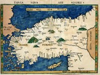
Of particular significance is the Ronald and Pamela Walker Collection of Maps of Asia Minor, numbering 135 original maps printed between 1511 and 1774, created by the finest European cartographers of that period.
Also available are some of the earliest cartographic representations of Australia with a concentration on Victorian material including a large number of Melbourne & Metropolitan Board of Works plans.
A wide range of maps including the complete Ronald and Pamela Walker Collection of Maps of Asia Minor is available for viewing online at: http://www.lib.unimelb.edu.au/collections/maps/digital/
